

Descripción
Descripción del estado: Ver imágenes. Marcas de edad. Oxidaciones.
Medidas totales: 59 x 49 cm. Medidas de la huella: 50 x 38 cm.
Gastinois et Senonois. Published in Amsterdam. The city of Orleans lies at the left margin along the Loire River. The Seine River is at the right. The city of Sens lies along the Yonne River.
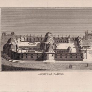
Antique map of France titled ‘Gastinois et Senonois’. Regional map of central France, northeast of Orleans showing the area between the Seine and Loire Rivers. Includes Auxerre, Sens, Nemours, Estampes, Corbeil, Melun, Pont Sur Seine, Montargis, Orleans, Briaire, Iainville, Pont Thierry, etc. This map originates from ‘Atlas Novus, Sive Theatrum Orbis Orbis Terrarum: In quo Galliae, Helvetiae (..)’ by J. Janssonius (1656-1657). Verso latín.